
Threat of Cyclone Amphan on India, High Alert in Eight States
Cyclone Amphan: Cyclone Amphan is coming; heavy rains may occur with strong winds
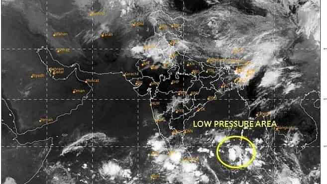
New Delhi: The Meteorological Department (IMD) has predicted cyclonic storm today i.e., Saturday. According to the forecast of the Meteorological Department, a low-pressure area is forming over the Bay of Bengal and near the South Andaman Sea, due to which cyclonic storm Amphan is likely in Odisha and adjoining areas on the evening of 16 May.
The Meteorological Department said that if it develops as a cyclonic storm, it will move north-east by May 17 and then it is likely to move north-west. At this time the wind speed can be 55-65 km per hour, which can increase to 75 km per hour.
Eight states already issued alerts
An alert from the Meteorological Department amidst Corona virus epidemic has raised concerns of eight states and union territories. In fact, the Meteorological Department has informed that this evening (May 16) a cyclonic storm Amphhan (Bay of Bengal) will come, due to which heavy rain may occur in Andaman and Nicobar, Odisha and West Bengal. Due to the impact of this cyclonic storm, heavy rains and strong winds can occur in eight states and union territories of the country.
Heavy rains may occur at these places
According to the Meteorological Department’s alert, Andaman and Nicobar Islands may receive heavy rains today and tomorrow. Apart from this, there may be heavy rains at some places in the coastal areas of Odisha and West Bengal. Fishermen have been advised not to venture into the sea in the south and central areas of the Bay of Bengal. Also, fishermen who have gone to these areas of the sea have also been instructed to return immediately. Along with this, an alert has also been issued in the coastal areas of Andhra Pradesh regarding cyclonic storm emphon. The coastal areas of the state may receive heavy rains and strong winds for the next 2-3 days.
Let us know that earlier on Thursday, the weather has changed in Delhi NCR after thunderstorms, rain and hail. On Friday, thunderstorm and rain are expected in many parts of the country including Delhi NCR.
Alert in 12 districts in Odisha
A low-pressure area in the Bay of Bengal may form a cyclone on Saturday. In such a situation, four coastal districts of Odisha have been asked to be on special alert, while alerts have also been issued for 12 other districts. As a precaution, all government holidays have been canceled.
Special Relief Commissioner Pradeep Jena said that the Meteorological Department has feared that the low pressure area could turn into a cyclone by Saturday evening. It will then move northwest and north-east by Sunday evening. However, where it will landfall is not yet clear. A vigilance notice has been issued for 12 districts from Gajapati to Mayurbhanj. However, after discussing with the District Collector of four coastal districts Baleshwar, Bhadrak, Jagatsinghpur, Kendrapada, they have been asked to be vigilant to deal with any situation.
These states were also alerted
According to the Meteorological Department, Western disturbance is active in the country at this time. Due to this, weather in the mountainous regions of the country like Jammu and Kashmir, Himachal Pradesh, Uttarakhand as well as Punjab, Haryana, North Rajasthan and Western Uttar Pradesh can be deteriorated. The meteorological department has issued an orange alert for these states. And people have been warned not to come out of the houses being cautious.
Chance of heavy rain at these places
According to the Meteorological Department, heavy rains are expected today and tomorrow in some parts of Andaman and Nicobar Islands, on Tuesday in some parts of coastal Odisha and in some places in West Bengal on Wednesday next week. On Saturday, there is a possibility of rain in many parts of Delhi and surrounding areas with dusty air.
Advice to fishermen not to go to sea in Odisha
Fishermen have been advised not to venture into deep sea in view of the possibility of cyclonic storm in Odisha. The meteorological department said that the low pressure area in the southeast of the Bay of Bengal turned into a high pressure area on Saturday morning and it is centered about 1,100 km south of Paradip in Odisha. Meanwhile, the state government has alerted 12 coastal districts and asked the district magistrates to make arrangements to take people there to alternate places. HR Vishwas, director of Bhubaneswar Meteorological Center, said that the high pressure area is expected to turn into a cyclonic storm by Saturday evening and then into a severe cyclonic storm during the subsequent 24 hours.
The impact of cyclonic storm will be seen for four days
He said that it is expected to initially move north-northeast by May 17 and then from May 18 to May 20 on the West Bengal coast towards the Bay of Northwest Bengal. Vishwas said that due to its effect, light to moderate rainfall is expected in coastal Odisha with heavy rain in remote areas on the evening of May 18 and very heavy rainfall in some places on May 19. He said that there is a possibility of heavy rainfall in northern Odisha on 20 May.